Map and Photo Essay
Map and Photo Essay (due Fri., Mar. 26)
Part 1: Map
Wearing a mask and staying at least six feet away from others, go out in your neighborhood (or a different one that is important to you) and spend at least one hour walking around (no more than a few blocks in each direction). Please remember that a park or other large open space is not necessarily a neighborhood. Parks can be part of a neighborhood, but I want you to survey an area with lots of human interaction (so, walking around a forest in the middle of Central Park, for example, won’t cut it).
Practicing all of the principles of ethnography (no judgments, suspend naive realism, etc.), conduct a walking observation by paying attention to:
● The built environment and landscape (What are they like? What does it suggest about the area and the social and/or power relationships that have produced and shaped them?)
● People’s interactions, their uses of space, their efforts to “make place” (What kinds of things do people do there? What kinds of things do they avoid? How do they treat and address each other? In what way, if any, have residents tried to make the community their own? What makes you think this?)
● Any symbols, artifacts, rituals, and other patterns that may carry meaning, in support of your insights about the previous two points, or any others you may think of during the observation. Be attentive to details that might have deeper meaning than appears at first sight.
● Take as many pictures as you can with your phone (or a digital camera, if you have one) of the most important visible signs and referents, especially those that you can connect with major themes about the neighborhood that you start to identify (Are there many new buildings, possibly for wealthier people? Is there a large non-English speaking, possibly immigrant, population? Is there a heavy police presence? etc.). You will later select the best five of these pictures for you Photo Essay (see Part 2, below).
Bring a notebook (make sure the pages are large enough to draw a map with all the required details described in the next paragraph) with you and jot down what you observe, even things that seem unimportant. You don’t need to submit these fieldnotes, but they will help you remember details and flesh out your ideas later on.
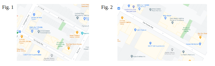
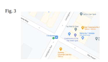
Select the most interesting block in the area observed, and draw a map of it.
define a ‘block’ as an area where people live, work, and interact that is:
● Bounded on four sides by streets (see, for example, Fig. 1); You may
● Both sides or a single street (include the corners) (see, for example, Fig. 2); or
● The four corners of an intersection (see, for example, Fig. 3).
The viewer must be able to identify clearly:
● All of the features of the built environment (buildings, parks, street, sidewalks, subway entrances, etc.), including their names if known (see below);
● The location of any major landmarks (specific kinds of building, murals, statues, fountains, trees, etc.) and other important, interesting, or relevant places on the block;
● The relative locations of any major symbols (graffitti, advertisements, signs, flyers, clothing, etc.), artifacts (cars, posts, containers, merchandise and other movable objects being used, etc.), and practices/patterns of behavior that you observed (for example: “a group of young people were skateboarding here”).
Your initial sketch will probably be rough, so go home and ‘clean it up’ either by hand, or with the help of a computer (the only requirements are that you make the map yourself —so NO screenshots from Google Maps like the examples above— and that you are able to convert it into a file format that can be uploaded to Blackboard). Make sure everything mentioned above is labeled legibly.
Scan or photograph your map (if drawn by hand), paste or insert the image into a Word file, and in the same file, type up a brief paragraph (250 words minimum) with any additional information or descriptions that might be helpful to the reader. Make sure you identify:
● The name of the specific neighborhood and the New York City borough it’s in (Manhattan, Brooklyn, Queens, The Bronx, orStaten Island);
● The names of all streets that appear on the map; and
● Names or a brief description of any important or outstanding buildings or other landmarks (if unsure, use Google Maps later on to corroborate). Upload the Word document (or convert it into a PDF first, if you’d like) through the corresponding link on the Assignments section of Blackboard.
Part 2: Photo Essay
When you go home after your walking observation, select the best five photographs (not just the best-looking, but the most interesting or meaningful ones, which tell a story) of different locations within the neighborhood (if possible, try to make sure they are all within the block you chose for your Map ; if they don’t, please say so clearly, and explain why not). If you prefer, you may return to the block you’ve selected at a later date. In this case, keep in mind any behavior observed may not be repeated, so always try to capture any interesting behavior in the moment, as long as it’s safe. You may want to take as many pictures as you can the first time, then come back for additional shots and/or anything you may have missed.
Once you have selected your five photos, paste or insert them all into the same Word file as the scan or photo of your map (please remember, the requirement is five photos in addition to the map NOT four photos plus the map), and type a brief caption (minimum 200 words each) for each photograph, in which you:
1) Provide the location, as detailed as possible, of each image, using street names and other references from your Mapping Exercise (for example: “Front entrance to the Julia de Burgos Cultural Center, on Lexington Ave. bet. 106th and 107th St”);
2) Explain its significance in terms of your research (An important historical landmark? An example of built environment, use of space, or place-making? An indication of how the neighborhood is changing?);
3) Use language as descriptive as possible (tell a story or ‘paint a picture’ with words); and
4) Try to connect the artifacts, symbols, and behaviors/practices in the image to key concepts that we’ve read about and discussed in class. (What does it mean for different groups of people who use this space? Is this a sign of gentrification? abandonment? deindustrialization? Does it represent a landscape of power and wealth, or one of marginalization? Perhaps an act of resistance by powerless populations? Is it an example of a culture of consumption? Are there visible signs of how the space was socially produced or constructed?)
Make sure you cite at least two readings and/or films from our class (don’t forget to include both in-text citations and a Reference List at the end). If you would like to use a key concept from a lecture that doesn’t appear in one of the readings, ask me (via email), and I will try to provide a source.
Upload the Word document (or convert it into a PDF first, if you’d like) through the corresponding link on the Assignments section of Blackboard.
IMPORTANT: Always make sure your document has been fully uploaded before you leave the submission page (sometimes students have trouble with this), and make sure you keep a copy of your work safely stored. Sometimes students claim they submitted something that isn’t showing up on Blackboard, but they no longer have a copy. Without evidence that the work was ever done in the first place, there’s nothing I can do.